Key info
| Location | Elan Valley Visitor Centre, Rhayader, LD6 5HP |
| County | Powys |
| Dams | 6 |
| Reservoirs | 6 |
| Sites of Special Scientific Interest | 12 |
| Annual visitors | 400,000 |
| Maintained by | Elan Valley Trust and Dŵr Cymru |
Visiting guide
Toilets
Café
Shop
Picnic areas
Birdwatching
Bike hire
Fishing
You can see the dams and reservoirs in any sequence; however, this guide will recommend them in the following order.
The following map details all car parks, dam locations, and additional points of interest including our favourite picnic spot.
How long does it take to see the Elan Valley dams & reservoirs?
You will require a car or coach to see all the dams and reservoirs in one day. If you are planning to walk the valley, accommodation is recommended, there are plenty of options in and near the valley.
It will take you roughly five hours to see every dam, have a picnic, and pop into the visitors centre. Bear in mind, there is plenty of driving between each dam so it’s best to arrive at the valley early in the morning.
If you are planning to visit during the winter, you’ll need to arrive at sunrise to make the most of limited daylight.
If you plan to arrive as a group, expect more time required to see the dams and reservoirs.
When is the visitor centre open?
Check the estate website for the visitor centre opening hours.
Is the Elan Valley suitable for a picnic?
There are plenty of spots to picnic. Our favourite would be next to the Pont Ar Elan bridge at the top of the Craig Goch reservoir. There are picnic benches overlooking the Elan river and the view of the valley can only be described as sublime.
It’s probably best to avoid picnicking near the dams because the falling water sprays into the air when they are flowing.
How do I get to the Elan Valley?
If you are arriving by public transport, head for Rhayader. The town no longer has a railway station; however, you can catch a train to Llandrindod Wells and then take a 30 min bus journey to Rhayader. There are bus services from Rhayader to Elan Village, which is where the visitors centre is located. Check out Traveline Cymru for travel info. You can always catch a taxi from Rhayader or Llandrindod Wells as an alternative option.
If you are visiting by car or coach, head straight for the visitors centre where you will be required to pay a parking charge.
How much is parking and how is payment accepted?
Check the estate website for the latest information about parking charges.
What wildlife can I expect to see?
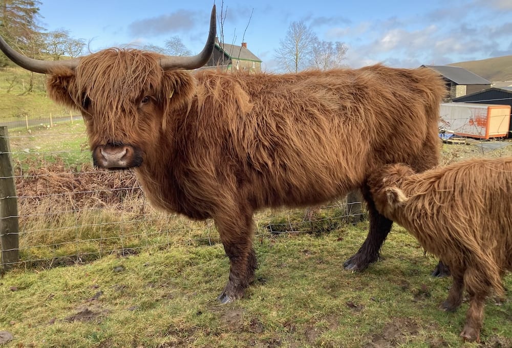
Elan Valley is an environment rich with wildlife. For more info on what to see, visit the website. You may encounter livestock when driving such as Highland Cows. Be sure to slow down to a crawling pace when driving past them.
Where are the toilets?
- Visitors centre
- Craig Goch car park
- Claerwen car park
- Penbont House near the Pen-y-Garreg car park
The dams and reservoirs
Ready to explore? Let’s begin!
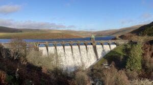
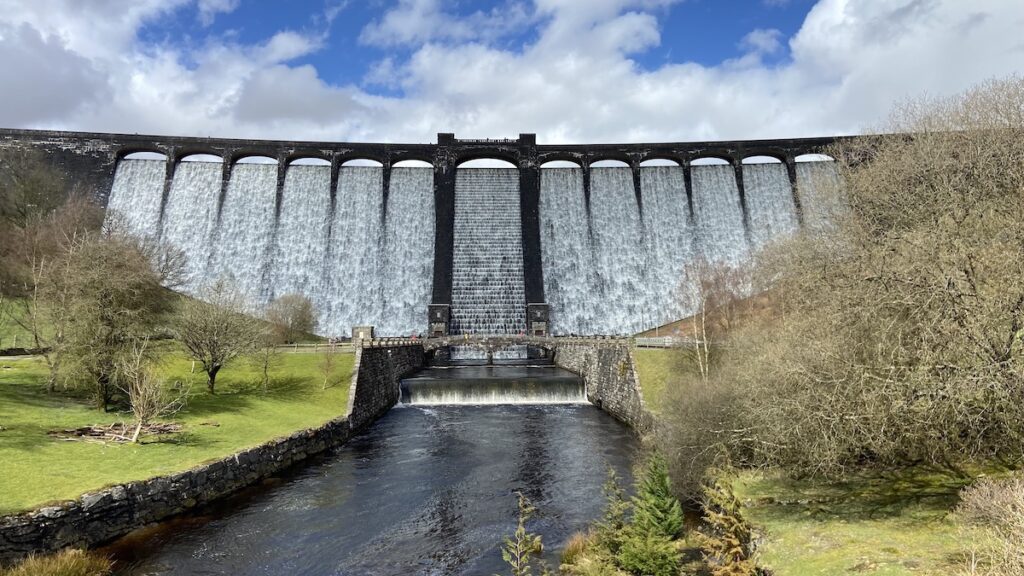
Caban Coch dam and reservoir
The Caban Coch (Welsh for ‘Red Cabin’) is the lowest out of all the dams. It was constructed to hold back water, which is used to balance the River Wye via the Elan River, which is a tributary. Therefore, the water in the Caban Coch reservoir is not used for the supply to Birmingham [2].
27 million gallons of water joins the River Wye daily. Before the water reaches the river, it passes through two powerhouses, one on each bank of the Elan River. They contain hydro-electric turbines, which provides power for the Elan waterworks [1].
Visiting guide
You can easily park in the adjacent car park on the northern bank of the dam. Here you’ll see the landscape scars left over from the Craig Gigfran quarry, which was one of two that supplied local stone for construction.
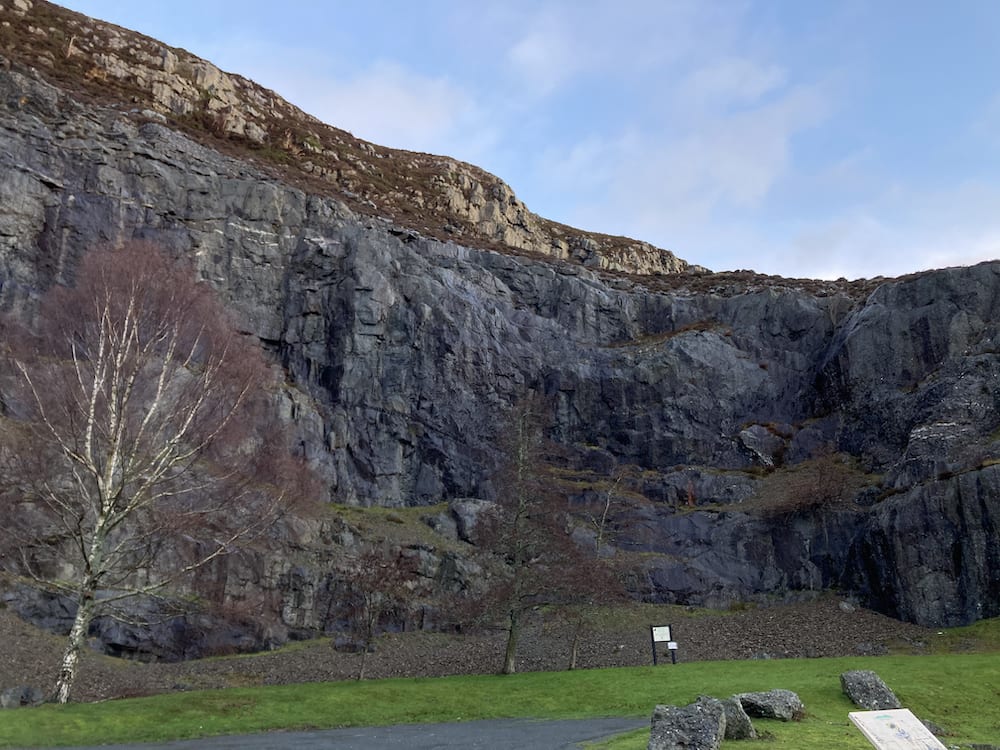
There’s a viewing platform next to the car park that offers a superb view of the water flowing over the dam (unless you are visiting during the dry season). You’ll see a pathway leading down to an arched bridge below that connects the two powerhouses. This is a great spot to enjoy the falling water and snap some awesome photos. Be mindful to wear a waterproof because of the spray from the dam.
Key info
| Resident engineer | George Yourdi |
| Completed | 1904 |
| Dam height | 122 ft (37.2 m) |
| Dam length | 566 ft (172.5 m) |
| Dam base thickness | 122.5 ft (37.3 m) |
| Dam listed status | Grade II* |
| Total electricity capacity | 1,070 kW |
| Total reservoir capacity | 7,815,000,000 gallons (35,530 megalitres) |
| Top water area | 500 acres (2 km2) |
Architecture
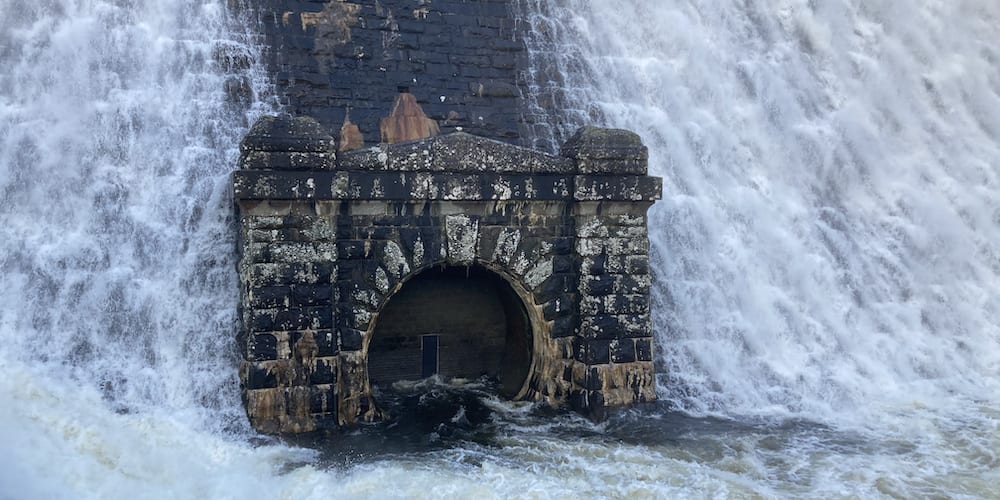
Caban Coch is a masonry dam with heavily rock-faced blocks. There are spillways with walls, which broaden as they drop and curve to become parallel with the river. When the dam is not flowing, you can see two rows of protruding blocks that were used to support scaffolding during construction. At the bottom of the dam, there are two circular outlets with a keyblock set in surrounds with piers to each end and a pyramidal pediment with tumbled blocks. Each end of the dam contains a platform with gigantic capstones worked to resemble natural rock [4].
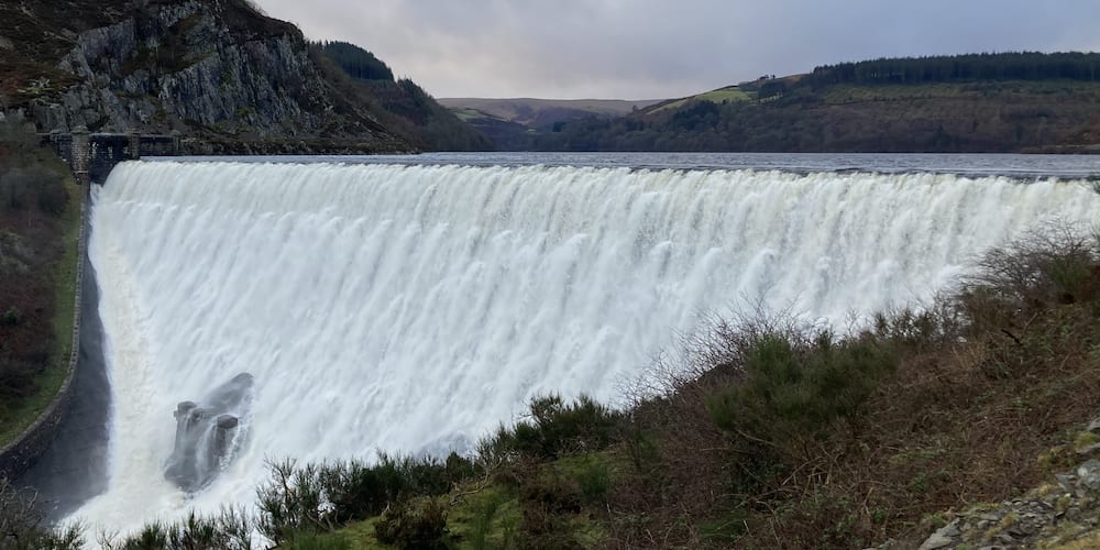
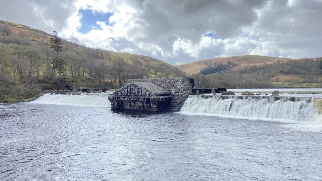
Garreg-Ddu dam and reservoir
This Garreg-Ddu reservoir (Welsh for ‘White Rock’) is where water enters the Elan Valley Aqueduct via the Foel Tower, which directs it to filter beds before journeying on to Birmingham. The chief engineer James Mansergh realised water would be a problem in the summer months [2]. If the level dropped too low, water would not be able to enter the tower and so the Garreg-Ddu Dam was constructed to maintain a minimum water level of 40 feet below the top level.
As a result, the dam is submerged when the water rises above. This is the reason why such a tall viaduct was constructed on top of the dam. The entire structure can be seen when the reservoir is low as shown in this photo.
In times of low water during the summer, the reservoir can be topped up from the Pen-y-Garreg and Craig Goch reservoirs upstream. There is also a tunnel next to the Dol-y-Mynach dam that directs water from the Claerwen Valley into the Garreg-Ddu [1].
Visiting guide
The car park is located on the south-western bank of the dam. Follow the south-east road and you’ll find a path leading up to the Nantgwyllt Church, which was built to replace an original that was flooded by the reservoir. The view from the church is stunning and a great place to photo the dam and Foel Tower in the distance. You may wish to visit the church if it’s open. It features the bell and lanterns from the original church before it was demolished to make way for the reservoir.
Walk across the dam for more beautiful views of the valley. You can then head across to see the Foel Tower, be mindful of vehicles when walking the roads.
Key info
| Resident engineer | Herbert Jefcoate Atkinson |
| Completed | 1904 |
| Total height | 123 ft (37.5 m) |
| Dam length | 417 ft (127.1 m) |
| Dam listed status | Grade II* |
| Total reservoir capacity | 1,320,000,000 gallons (6,000 megalitres) |
Please note the dimensions above were taken from an unofficial source as we have yet to find verified information.
Architecture
Garreg-Ddu consists of a rock-faced brown stone viaduct resting on a submerged dam. There are five narrow arches to the north-east and seven broader elliptical arches in the centre. The parapet consists of large rock-hewn capstones to each end [5].
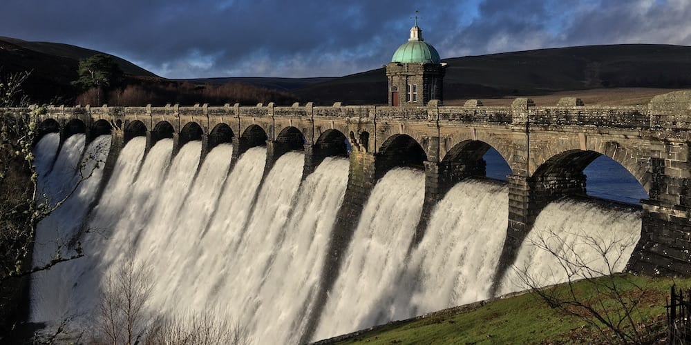
Pen-y-Garreg dam and reservoir
This dam is named after the nearby Pen-y-Garreg farm (Welsh for ‘Above the Stone’), which lost some of its lands to the reservoir after initial flooding [1]. The dam is unique in that its valve tower is located in the centre.
Visiting guide
The car park is a ten-minute walk from the dam next to an arched bridge near Penbont House. Walk along the river to the base of the dam where you will get a magnificent view of the dam outlet close-up and hear the roaring thunder of water as it gushes down. There are steps to the left, which will take you up to the viewing platform south of the dam.
Key info
| Resident engineer | Eustace Tickell |
| Completed | 1903 |
| Dam height | 123 ft (37.5 m) |
| Dam length | 528 ft (160.9 m) |
| Dam base thickness | 115 ft (35.1 m) |
| Dam listed status | Grade II* |
| Total electricity capacity | 810 kW |
| Total reservoir capacity | 1,332,000,000 gallons (6,055 megalitres) |
| Top water area | 124 acres (0.5 km2) |
Architecture
The dam wall and spillway of Pen-y-Garreg is very similar to Caban Coch. There are some differences, for example, at the bottom of the dam, there is only one circular outlet with a key block set in an aedicule-like surround with piers to each end and a pediment. There are also platforms at each end of the dam with steps leading down to the river. At the centre of the dam is an octagonal valve tower with a copper dome containing waterspouts around its circumference. The dome is adorned with a lantern and fish weathervane. The interior is said to contain original operating machinery [6].
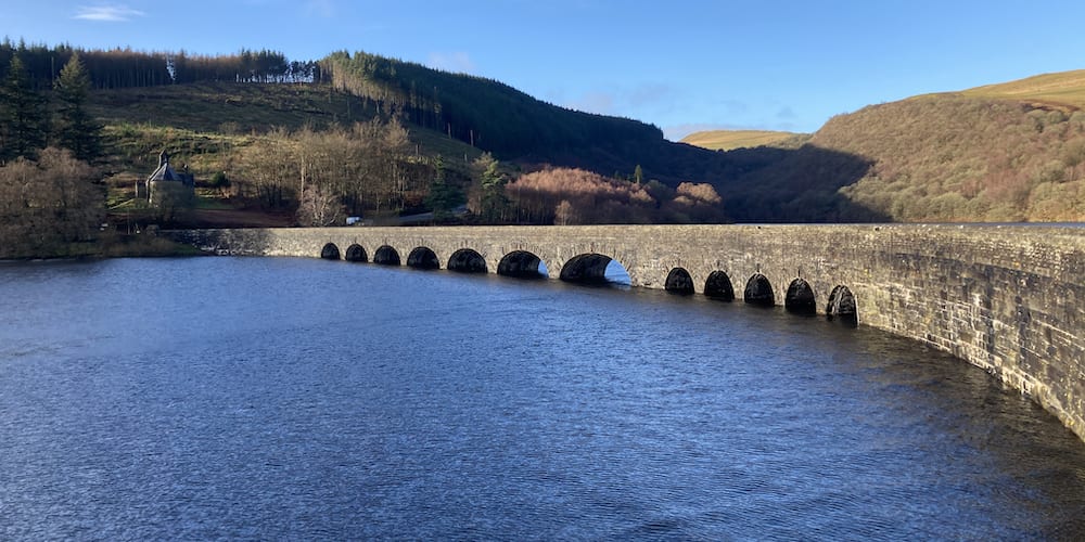
Craig Goch dam and reservoir
Craig Goch (Welsh for ‘Red Rock’) is the highest reservoir in the Elan Valley. The curved dam is arguably the most beautiful and it featured in the Welsh police detective drama Hinterland.
Visiting guide
Park up on the east side of the dam then walk across to enjoy the detail of its valve tower, the ornate arched viaduct, and the stunning views of the Elan Valley in all its glory. Be mindful of vehicles when crossing the dam and use the refuges where possible.
You can also walk past the gate and follow the road down to the river at the bottom for a close-up view of the dam. There are toilets next to the car park.
Key info
| Resident engineer | George Yourdi |
| Completed | 1903 |
| Dam height | 120 ft (36.6 m) |
| Dam length | 513 ft (156.4 m) |
| Dam base thickness | 104 ft (31.7 m) |
| Dam listed status | Grade II* |
| Total electricity capacity | 480 kW |
| Total reservoir capacity | 2,028,000,000 gallons (9,219 megalitres) |
| Top water area | 217 acres (0.9 km2) |
Architecture
Craig Goch is a curved masonry dam with heavily rock-faced blocks. The spillways are similar to those on the Caban Coch and Pen-y-Garreg dams. The Craig Goch supports a viaduct on 13 arches that carry the roadway. The viaduct features contrasting rock-faced and smoother stone with piers supporting segmental arches containing keystones and a parapet with coping and heavy rock-faced capstones. There is a band course at road level and polygonal refuges three arches from each end. The dam also has an attached polygonal valve tower very much like the Pen-y-Garreg [7].
Claerwen dam & reservoir
Claerwen dam and reservoir is the largest in the Elan Valley Estate and the last to be constructed. The dam and reservoir was the eventual solution for the second phase of expanding the water supply.
Dol-y-Mynach dam & reservoir
Dol-y-Mynach Dam is the only unfinished dam in the Elan Valley Estate. The dam was meant to be one of three for the second phase of expanding the water supply. Construction started but was paused. Advances in construction technology meant it was no longer a viable solution and so the unfinished dam still stands to this day acting as a weir for the small Dol-y-Mynach Reservoir.
Sources
- Brown, D. L. (2020) The Elan Valley Clearance. Eardisley: Logaston Press.
- Morton, R. (1997) The Building of the Elan Valley Dams. Walsall: Brian Lowndes Print.
- Elan Valley Trust (2021) The Dams. Available at: https://elanvalley.org.uk/explore/the-dams/ (Accessed: 26 Feb 2021).
- CADW – 16202 – Caban Coch Dam
- CADW – 16200 – Carreg Ddu Viaduct and Submerged Dam
- CADW – 16199 – Penygarreg Dam & Valve Tower
- CADW – 16198 – Craig Coch Dam & Valve Tower
- Coflein – Dol-y-Mynach Reservoir, Elan Valley Water Scheme
- CADW – 16222 – Claerwen Dam, including attached footbridges
- CADW – 16201 – Foel Valve Tower
 Sandwell Park Colliery Trail